Categories
Month: November 2022
Categories
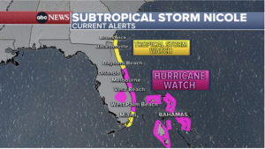
Sub-Tropical Storm Nicole
Residents should make preparations for Sub-Tropical Storm Nicole. We therefore recommend that all boats and other property that is at risk of damage or becoming a projectile be secured. In addition we urge that all construction material be secured and debris removed or covered. We also advise following these guidelines if appropriate in the event that the storm is upgraded to a hurricane:
What to do now
- Prepare an Evacuation Plan.
- Be certain you have adequate insurance on your home and its contents. This should include Flood Insurance through your home insurance carrier and wind and hail coverage. Review your insurance coverage in detail with your agent.
- Ask your insurance agent or company what you can do to reduce your chance of loss, such as installing hurricane shutters.
- Photograph or videotape your home and contents for insurance purposes.
- Make copies of family and personal records.
- Do not assume that the government will be able to provide for your needs. You must take steps to be self-sufficient. Be prepared: Make sure you have food, clothing, medication, and other supplies available for a week or more. During an emergency or recovery operation, public agencies will be flooded with requests for assistance. Resources will be and should be directed to the most vulnerable and needy members of the greater community.
When a hurricane watch is issued
- Keep tuned to a local radio or television station for the latest National Weather Service advisories, as well as special instructions from local government.
- Check battery-powered equipment. Your battery-operated radio could be your only source of information, and flashlights will be needed if utility services are interrupted. Buy extra batteries.
- Keep your car fueled should evacuation become necessary. Also, service stations may be inoperable after the storm strikes.
- Store drinking water in clean bathtubs, jugs, and bottles as the water system may be contaminated or damaged by the storm.
- Obtain extra prescription medications and medical supplies.
- Many people board their windows or protect them with storm shutters. Windows are broken mainly from wind-driven debris. Wind pressure may break large windows, garage doors, and double-entry doors. The taping of windows does not keep the glass from breaking; it merely keeps broken glass in a more confined area. If desired, install hurricane shutters/window boards on all unprotected windows. This may prevent tree limbs or debris from breaking windows.
- Secure outdoor objects that might become debris. Garbage cans, garden tools, toys, signs, porch furniture, and a number of other harmless items become deadly missiles in hurricane winds.
- Fasten your boat securely well before the storm arrives, or move it early to a designated safe area. We suggest tying an anchor into the middle of the canal for the bow line and another for the port in order to prevent the boat hitting the bulk heads or ending up on the bank. Do not stay on the boat.
- Trim back dead wood from trees and remove branches and coconuts from coconut trees.
- Park extra vehicle(s) in the garage and remove any from carports.
- If you have a swimming pool, cover the pump filter.
- If told to do so, shut off water, electricity, and gas
- Turn off gas at any outdoor propane tanks.
- Take down flags that may be flying.
- Disconnect power and cable to your television sets, but keep one set on to receive last minute news and instructions.
- Do not leave any pet(s) outside or tied up during a hurricane.
- Make certain pets are wearing collars with current ID. Use adhesive tape and an indelible pen if ID is not current, and tape to pet’s collar.
- The floods and flash floods brought by the torrential rains of a hurricane are dangerous. Even though hurricanes weaken rapidly as they move inland, the remnants of the storm can bring 6 to 12 inches of rainfall to the area it crosses. Sandyport Drive is prone to flooding so please take the necessary precautions.
During the hurricane
- TAKE COVER – Remain indoors during the hurricane. Blowing debris can injure and kill. Travel is extremely dangerous. Be especially aware of the “eye” of the hurricane. If the storm center passes directly overhead, there will be a lull in the wind lasting for a few minutes to a half hour or more. At the other side of the eye, the winds will increase rapidly to hurricane force and will come from the opposite direction.
- STORM SURGE – Storm surge is a great dome of water often 50 miles wide, which sweeps across the coastline near where the eye of the hurricane makes landfall. The surge, aided by the hammering effect of breaking waves, is like a giant bulldozer sweeping everything in its path. The stronger the hurricane, the higher the storm surge. This is unquestionably the most dangerous part of the hurricane. Nine out of ten hurricane fatalities are caused by the storm surge.
- FLOODS – The floods and flash floods brought by the torrential rains of a hurricane are dangerous killers. Even though hurricanes weaken rapidly as they move inland, the remnants of the storm can bring 6 to 12 inches of rainfall to the area it crosses. The resulting floods have caused great damage and loss of life.
- WINDS – The winds of a hurricane (74 miles per hour or more) can be very dangerous. For some structures, wind force is sufficient to cause destruction. Wooden structures are particularly vulnerable to hurricane winds that can spawn tornadoes, which contribute to incredible destruction. The greatest threat from hurricane winds is their cargo of debris—a deadly barrage of flying missiles such as lawn furniture, signs, roofing, trees, siding, etc.

